


In order to develop a detailed geological understanding of a region, and efficiently target exploration efforts, it is important to bring together modern technologies from a range of disciplines. Increasingly, data acquired from orbiting satellites are supporting upstream activity, providing unique information for areas that are often remote or inaccessible.
During the exploration stage of a project, data from Synthetic Aperture Radar (SAR) satellites can contribute to identify oil on the sea surface sourced from natural seeps. This is a proven approach that has been used by oil companies worldwide to explore frontier basins offshore and for the re-evaluation of mature fields.
Global Seeps Database – Reducing Frontier Exploration Risk
Technology for reducing risk in the assessment of frontier areas is valuable during the early stages of oil and gas exploration. In the offshore environment, oil slicks on the sea surface sourced from oil seeps on the sea bed give an indication of a working hydrocarbon system. Radar imagery provides a reliable method for identifying and monitoring sea surface slicks by observing the dampening effect oil has on amplitude of any surface waves.
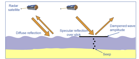
Pic. 1. Methodology for oil seep identification on water-bodies, based on the Radar backscatter reduction caused by the dampening effect of oil on wave amplitude
Using TerraSAR-X and other sensors, Airbus Defence and Space has produced a global database of oil slicks over the last 25 years, containing over 21,000 radar scenes and over 25,000 potential oil seeps. Critical to the identification of surface slicks is the repeat coverage offered by the radar data. By observing a slick on multiple dates, over a period of a number of years, greater confidence can be assigned to the feature as being a natural oil seep, as opposed to transient oil pollution from shipping. Slicks are given a confidence level by experienced analysts according to the morphological characteristics, context and repeatability.
As repeat coverage is critical in increasing the confidence level of previously identified slicks, and for identifying discontinuous seepage events, emphasis is placed on adding new scenes to the database. Over 5,000 new scenes were added to the database during 2014-2015 as part of a major update and updates are set to continue in the coming years as new areas are assessed and existing areas of coverage are revisited with Airbus Defence and Space committing to analyse a minimum of 2,000 new scenes per year. TerraSAR-X is also being leveraged to acquire imagery in areas of the World lacking radar coverage or for specific customer studies.
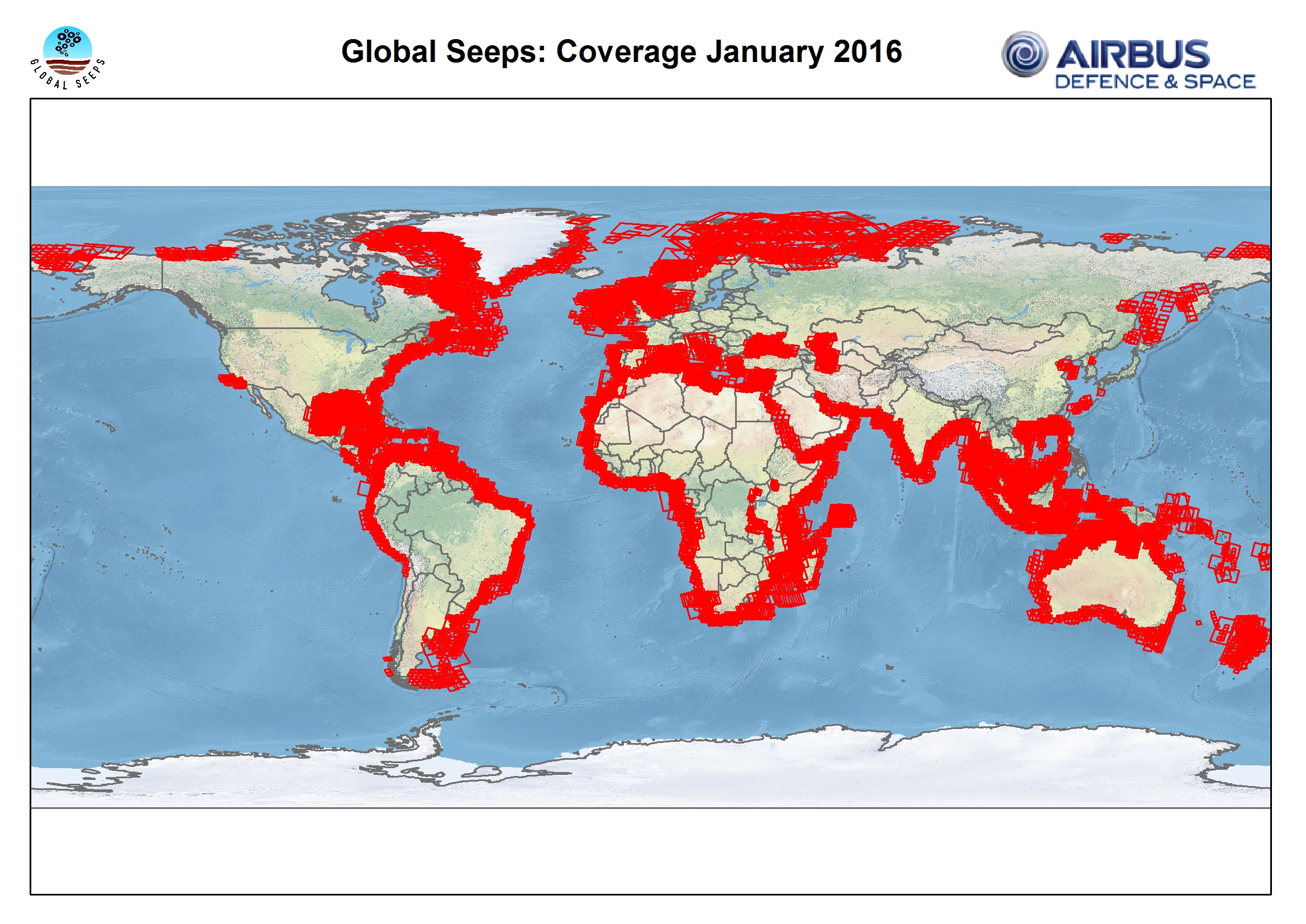
Pic.2. Coverage diagram of the Airbus Defence and Space Global Offshore Seeps Database. Red polygons indicate individual radar scenes contained within the database
Seep locations are commonly integrated with a variety of other geological and geophysical datasets to aid the understanding of potential exploration targets. Comparisons with seismic data have shown a strong correspondence between higher confidence slicks and structural features together with direct hydrocarbon indicators. Surface slick locations can be an important input into seismic planning processes, and clients have adjusted their planned seismic lines to correspond to locations of known seeps.
Geochemical sampling of surface slicks can be limited by difficulties in locating slicks if they are episodic or influenced by strong currents. TerraSAR-X radar imagery can be used to guide geochemical sampling in near-real-time by tasking and rapidly providing imagery and interpretation layers directly to sampling teams on boats within the survey area. This approach increases the likelihood of a successful sampling program and has been shown to be particularly valuable when combined with historical archive data of likely seepage locations.
Cost-effective offshore operations
The extensive costs related to offshore activities remain any cost-effective tools available to make their operations more streamlined. This explains why offshore oil seep detection using SAR satellites is an increasingly established method for assisting in the reduction of exploration risk for offshore frontier basins or for re-evaluating previously explored regions.
As an example, exploration efforts are gearing up around the Adriatic coast of Croatia, with licensing rounds in recent years. Airbus Defence and Space and seismic multi-client acquisition and imaging specialists Spectrum Geo, collaborated to produce a joint study correlating natural oil seeps identified from radar and optical satellites with 2D seismic data to assist hydrocarbon exploration in this Adriatic Basin. Results suggested a strong correlation between higher confidence slicks and structural features interpreted from a Spectrum Geo’s 2D seismic survey acquired offshore Croatia in 2013, allowing the targeting of further exploration work.
In a separate study conducted for Nalcor Energy Oil & Gas division to assist in the assessment of prospectivity of offshore Newfoundland and Labrador, slick locations have been used to help focus future exploration efforts in the region.
Offshore Activity Monitoring
Satellite imagery is also a very powerful tool for regular monitoring. A pilot test has recently been carried out over an offshore region in Angolan waters covering several thousand square kilometres, with daily acquisitions performed over an 11-day period.
The aim was to use a combination of radar and optical data to image and identify all offshore activity including static oilrigs and drillships as well as support vessels and tankers. Oil slicks were also documented and classified. Both the optical and radar constellation were leveraged, adapting the tasking strategy to the weather conditions: radar satellites for example when weather conditions led to thick cloud cover or optical satellites for the highest resolution imagery when clear weather conditions allowed high visibility.
Optical images from the Pléiades satellite were used by analysts to identify ship traffic entering the area around production vessels, and classify whether they were tankers, support vessels or drillships. During the trial an oil slick was identified from images taken by the SPOT 6 satellite, with the slick tracked to a Floating Production, Storage and Offloading unit (FPSO). Through accurate and regular imaging it was possible to plot the course and progress of the slicks. Bespoke maps were compiled showing slick locations and related features.
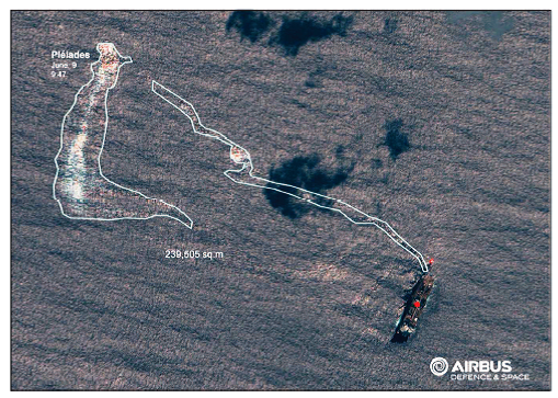
Pic.3. Oil Slick viewed by Pléiades satellite, © Cnes 2015, Distribution Airbus DS
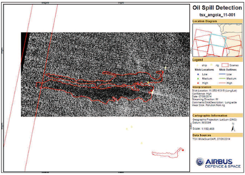
Pic.4. Oil spill detection by TerraSAR-X satellite, © DLR e.V. 2015, Distribution Airbus DS Geo GmbH
The combination of radar and optical surveillance tools, proved particularly effective. Radar satellites, such as the TerraSAR-X operating in Wide ScanSAR mode (40m resolution for image sizes up to 270km per 200km) are effective for leakage detection over large areas of open sea. As previously mentioned when identifying natural seeps, this detection is based on the mirroring effect oil slicks have on the water’s surface, as waves are dampened by the oil presence, while optical sensors can identify the smallest items in high resolution.
In addition, offshore and near-shore infrastructure and facilities are vulnerable to hostile acts, with regular satellite monitoring having the potential to provide situational awareness. Attacks on offshore facilities may cause oil leaks from drilling rigs, FPSOs or platforms – similarly threatening risk to personnel together with significant environmental and commercial impact
Relative posts


Comments