


Right now the remote Arctic region’s ice levels are slowly recovering after the summer months bring about all-time lows, allowing for an increasing amount of ships to transit through these relatively untouched waters. The ice retreat means Arctic research and exploration ramps up as nations begin to unearth the resources that lie beneath this frigid temple.
Just as ships in the Arctic maneuver around the melting ice caps, off the coast of Australia in the beautiful turquoise waters of the Great Barrier Reef, massive tanker ships are travelling dangerously close to this pristine world wonder. In fact, ships everywhere in the world are dancing around similar environmentally safe zones known as Marine Protected Areas, carefully travelling out of harm’s way so as not to disturb the marine life that calls these areas home.
Across the poles and everywhere in between, exactEarth has their eyes on our oceans. Knowing the who, what and where of shipping activity is precisely their business. Operating their own constellation of seven low-earth orbiting satellites, exactEarth is able to detect the transmitting signals from more than 165,000 active vessels across our oceans. Every ship over a certain gross tonnage is required to be fitted with an AIS (Automatic Identification System) transponder that emits messages containing information like the ship’s position, course, and speed. exactEarth is able to then take those messages, almost 8 million a day, and decode them into actionable data for its users. Competent maritime authorities around the world have been loyal to the exactEarth data service, exactAIS® since the company launched in 2009.
Starting with just one satellite back then, exactEarth is now able to provide complete global coverage with their current exactView constellation but is not stopping there. With two planned launches in the fall of 2015, exactEarth will add an equatorial satellite to the mix to significantly lower the current global revisit times of the satellite constellation.
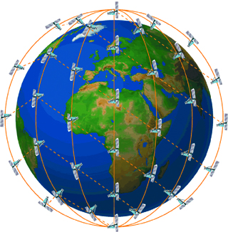
Pic.1. Illustrated representation of the Iridium NEXT constellation
Constellation expansion was the major driving force behind exactEarth’s recent announcement of a new partnership with Harris Corporation, as they will be first to market a real-time (RT) satellite AIS constellation. The new exactView RT powered by Harris will leverage the real-time connectivity of 58 hosted payloads on the Iridium NEXT constellation.
At full deployment, the exactAIS service will be utilizing a combined constellation of near 70 satellites, providing a new level of satellite AIS (S-AIS) data service for real-time global ship tracking. exactView RT powered by Harris will offer customers both data latency and global revisit times under one minute, allowing them to offer truly unsurpassed global ship tracking and maritime information solutions.
“As the recognized satellite AIS industry leader, the Harris announcement further strengthens our commitment to provide best-in-class maritime intelligence solutions to our customers worldwide,” said Peter Mabson, President of exactEarth. “We are thrilled to be able to offer the shortest revisit times and lowest latency for developing true maritime domain awareness. This partnership with Harris will allow us to significantly expand the range of advanced value-added services and information solutions that we can bring to the global maritime market.”
The next generation S-AIS constellation utilizes exactEarth’s proven and patented AIS spectrum decollision algorithms to make sense of those millions of AIS messages received as well as the reconfigurable Harris AppSTAR™ payload platform. The ability to reprogram the payloads from the ground is a real boon for the team at exactEarth as they now can support multiple onboard applications to adapt to the ever-changing maritime industry. By hitching a ride on the Iridium NEXT constellation, exactEarth will now have access to the entire maritime VHF band as well as new and future digital modes and services. This opens the door to a whole host of other VHF-based vessel data services such as container tracking and monitoring, emissions and fuel usage data, fish catch data as well as the collection and supply of weather and navigation data.
With AppSTAR’s reprogrammability built into the processing elements, on-orbit reconfigurations and repurposing are easily accomplished via software uploads. This provides complete operational flexibility, enabling exactView RT to adapt to changing VHF missions and/or mission parameters. With extra processing capability built into the space payload, Harris and exactEarth have room to expand the capability of the exactView RT system towards new and changing signals, missions and uses.
To date, exactEarth has seen their data used by authorities for building credible maritime domain awareness (MDA) in a whole host of operational activities. In an ever-changing environment where there is a vital need for the persistent monitoring of human activity to forecast defence challenges, S-AIS has become a very powerful tool in the delivery of MDA to a variety of maritime and geo-intelligence users. S-AIS is evolving in the context of Activity Based Intelligence (ABI) as a crucial aid to effective decision making and proactive response to ensure national defence and security, as evidenced by data being easily correlated with other information sources, such as a Radar or Electronic Support Measures (ESM) signature. The ability to readily know the who, what and when of any transiting vessel is a critical piece of intelligence. S-AIS provides that knowledge for any area of interest and has been a benefit for maritime operations, whether it’s monitoring protected areas, better mapping of remote regions, conducting search and rescue operations or combatting illegal fishing.
Fisheries now play an important role in improving food security and supporting economic development, provided that fisheries management is effective in curbing illegal fishing. Illegal, unreported, and unregulated (IUU) fishing is a global problem that threatens ocean ecosystems and sustainable fisheries. The United Nation’s Food and Agriculture Organization (UN FAO) reports that 52% of the world’s marine fishery resources are fully fished or fished to the maximum sustainable level. IUU fishing is a major threat to achieving sustainable fisheries. Furthermore, IUU fishing jeopardizes a multi-billion-dollar industry. IUU vessels operate in areas populated with legitimate fishing vessels and in order to counteract IUU activities, it is critical to improve monitoring technologies.
In March of 2015, exactEarth provided data to the Federal Ministry of Fisheries and Marine Resources in Somalia as the nation looks to build the infrastructure necessary to combat the rampant IUU fishing taking place in their waters. In order to build their case for fishery management resources, the Ministry compiled many examples of illegal fishing activities within the EEZ using data from exactEarth.
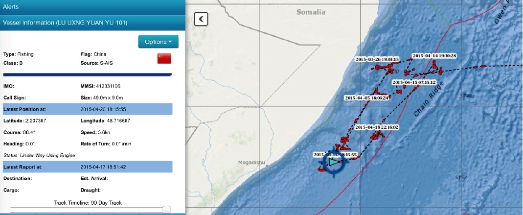
Pic.2. Seven tuna longliners from China had been operating in the EEZ of Somalia during the month of March without requesting authorization to enter the waters or even applying for a fishing license. One was the Lu Qing Yuan Yu 101 (track shown to the right)
With the addition of real-time data, authorities can expect to have an even bigger leg up in the daily execution of maritime operational activities. Considering that behavioural modeling can now be performed in real time, dark target analysis is significantly enhanced as authorities can instantaneously see any deviation in a vessel’s traffic pattern. Authorities can know instantly when a ship has turned off its AIS, signaling a boat that may be trying to hide its position. That same instantaneousness can be applied to catching illegal fishing in its tracks or spotting a ship breaching an environmentally sensitive zone. The real-time data provides authorities with the actionable information they need to not only identify suspect ship behaviours but enough time to act on that information. Real-time data allows for an analysis that can reveal illegal activities on the ocean such as violating fishing laws, contaminating or destroying marine habitat and breaching into Marine Protected Areas.
Authorities need to be able to monitor vessel activity in and around these ecologically sensitive areas to help preserve the marine environment. With real-time data at their fingertips, authorities can identify vessels with pre-defined courses set to traverse through MPAs, enabling corrective ship routing measures to prevent unnecessary breaches. This type of precautionary approach ensures that not only are MPAs protected but vessels can be held accountable.
Quick response times are a requirement when it comes to search and rescue operations where the new real-time data can be a matter of life or death. Now coordinators will know immediately when and where a ship is in distress to allow for the most efficient use of resources such as patrol craft since the rescue area is pinpointed. Proactive rescue responses will be a reality as authorities monitoring ships traversing through stormy weather conditions can be immediately notified at any sign of trouble.
The Arctic is home to some of the most dangerous weather conditions for modern shipping and with much of it covered in varying levels of sea ice; it is prone to poor visibility for vessel traffic. Traditional coastal-based AIS systems cannot provide the coverage and surveillance of the region that is required as more and more traffic enters the notoriously hazardous region. With close to 70 satellites overhead, exactEarth will offer constant, overlapping coverage in the Arctic, providing a rich understanding of Arctic maritime traffic trends and immediate alerting of vessels entering the perilous regions. Now armed with real-time data, officials can closely monitor all traffic ensuring the safest routes are followed and can be immediately notified when ill-equipped vessels enter into the Arctic region.
exactEarth continues to see businesses and organizations rely on global satellite AIS data in so many different activities, and with real-time data now a reality, exactEarth customers around the world can expect to make drastic improvements to their maritime safety, security, and use of marine assets.
Relative posts


Comments